What Are the Top Natural Forces in Global Trade?
Global trade rarely moves in a straight line. It follows coastlines, seasons, rivers, resource deposits, and human demand. These natural forces influence where goods are grown, processed, stored, and shipped. A container of coffee may begin on a highland farm, travel by truck, and cross an ocean before reaching a city café. A drought can tighten supply within months. A navigable river can lower transport costs for generations. These details make trade less abstract and more measurable.
This overview examines the top natural forces shaping international commerce. Geography remains powerful because distance, terrain, and port access affect cost and reliability. Climate determines harvest windows, energy needs, and exposure to storms. Fresh water, fertile soil, minerals, and fisheries support entire export industries. Population patterns also matter, although they are not purely natural. They interact with land, infrastructure, and changing consumer habits.
Reliable analysis requires more than listing influences. It must compare trade statistics, shipping records, climate data, and industry experience. The links are not always neat. A rich resource base may attract investment, yet weak roads can delay deliveries. A warm climate may support production, but extreme heat can reduce yields and threaten worker safety. Trade policies and technology can soften natural constraints, but they rarely erase them.
The discussion ahead considers which forces matter most, where their effects overlap, and why their importance changes by product and region. It also questions easy assumptions. Nature sets conditions, not fixed outcomes. That distinction is easy to miss.
Geography as the Foundation of Global Trade Routes
What Are the Top Natural Forces in Global Trade?
Geography as the Foundation of Global Trade Routes
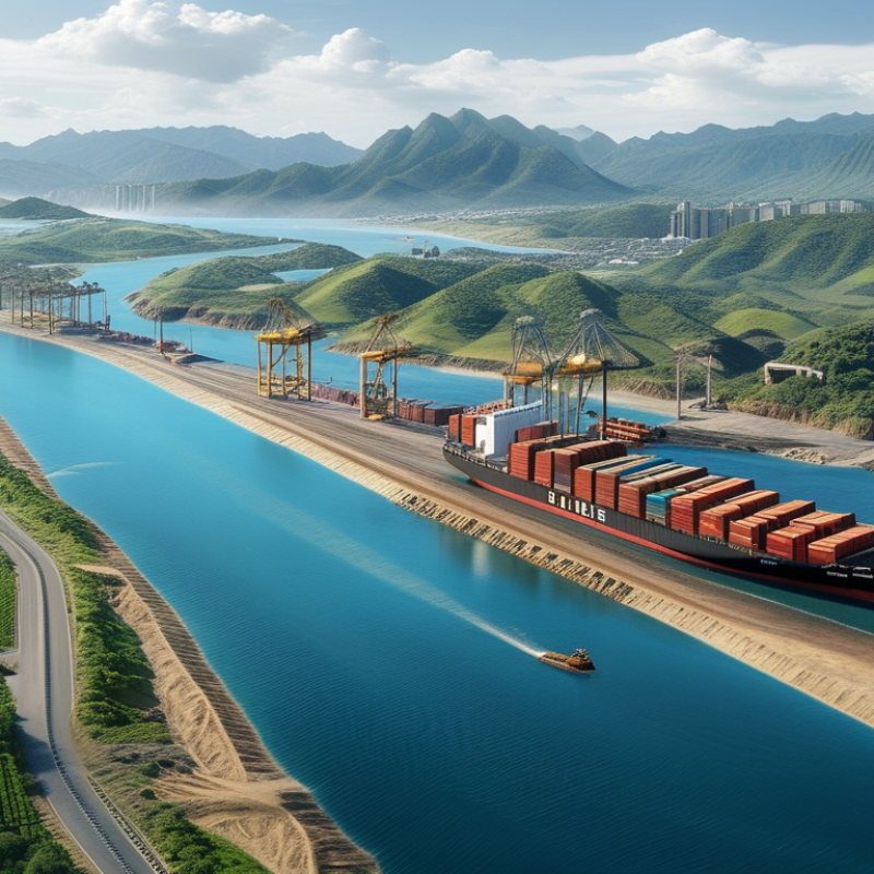
Geography quietly determines where global trade begins, moves, and slows. Mountain ranges create difficult crossings and concentrate traffic through narrow passes. Rivers offer cheaper inland transport, especially where roads remain limited. A navigable river can connect farms, mines, and cities across thousands of kilometers.
Oceans shape the largest trade routes. Prevailing winds and ocean currents once guided sailing vessels, while modern ships still follow deep channels and sheltered coastlines. Natural harbors reduce construction challenges and protect vessels from heavy waves. Flat coastal land also supports warehouses, rail lines, and customs facilities. In field surveys, port planners often examine tides, seabed depth, erosion, and storm exposure before expanding a terminal.
Climate adds another layer of uncertainty. Seasonal ice can close northern passages for months. Monsoon winds may accelerate travel during one season and delay it during another. Drought can lower river levels, forcing vessels to carry less cargo. Heat can also damage roads and rail tracks. These details feel local, but their effects spread through international supply networks.
Geography is powerful, not absolute. Engineering can tunnel through mountains or deepen a channel, but such projects require time, money, and careful environmental assessment. Maps can also mislead. A short route is not always a practical route. Security, weather records, and maintenance needs matter. Trade planners must keep revising their assumptions as coastlines erode and climate patterns shift.
Climate and Weather Patterns Shaping Trade Activity
What Are the Top Natural Forces in Global Trade?
Climate and Weather Patterns Shaping Trade Activity
Climate and weather patterns quietly govern global trade. Drought can reduce harvests, raise food prices, and increase pressure on inland transport. Heavy rain may flood roads, railways, and storage facilities near major production areas. Tropical storms can suspend port operations within hours. Wind matters too. Strong gusts can delay vessels, damage cargo equipment, and create unsafe working conditions. These disruptions often spread beyond one region. A delayed shipment can affect factories, retailers, and consumers thousands of miles away.
Trade planners now combine seasonal forecasts, satellite observations, river levels, and port updates. This approach improves preparation, but forecasts are never promises. El Niño and shifting monsoon patterns may bring unusual heat or rainfall. A dry river can limit vessel capacity, while extreme heat can damage roads and reduce worker productivity. In practical supply planning, flexible routes and realistic buffer times are essential. Still, companies sometimes overestimate their readiness. That deserves honest review.
Tips: Track weather warnings daily. Use more than one transport route. Check river and port conditions before booking time-sensitive cargo. Store critical materials in cooler, elevated locations when possible. Keep communication plans simple. Small delays can become expensive.
Natural Resources Driving International Supply and Demand
International trade begins with physical resources, not spreadsheets. Oil, natural gas, grain, copper, lithium, and freshwater shape supply and demand across borders. A copper cathode may travel from a mine to a smelter, then into kilometers of electrical cable. The chain is long. It is also fragile.
Energy remains the strongest natural force. The International Energy Agency’s World Energy Outlook 2024 links rising electricity demand to industry, cooling, transport, and digital infrastructure. The IEA’s Global Critical Minerals Outlook 2024 projects lithium demand could grow roughly ninefold by 2040 under current policy trends. This shift increases pressure on mines, processing plants, ports, and local water systems. Supply cannot expand overnight. That sounds obvious, but markets often behave otherwise.
Food adds another powerful pressure. The Food and Agriculture Organization estimates agriculture uses about 70% of global freshwater withdrawals. Drought can reduce exports before prices fully react. The World Bank’s Commodity Markets Outlook shows how energy and food prices remain sensitive to weather, conflicts, freight costs, and policy changes. Maritime transport carries over 80% of world merchandise trade by volume, according to UNCTAD’s Review of Maritime Transport 2023. One delayed vessel can disrupt distant factories. Forecasts still miss uncomfortable details, especially soil damage and regional water stress. More data helps, but it does not remove uncertainty.
Oceans, Rivers, and Ports Connecting Trading Regions
What Are the Top Natural Forces in Global Trade?
Oceans remain the broadest highways for global trade. Their deep channels carry heavy cargo between distant trading regions. Seasonal storms, currents, and changing water levels affect schedules and operating costs. A port may look calm at sunrise, yet strong winds can delay loading by hours. Rivers create different advantages. They move farm goods, minerals, and manufactured products inland with less fuel than long road journeys. However, narrow channels and dry seasons can restrict access. Trade depends on geography, but also on careful local knowledge.
Tips: Check water depth, weather records, and seasonal river patterns before planning routes. Allow extra time near exposed coastlines and crowded port entrances. Small details matter.
Ports connect these natural systems. They transfer cargo from ocean vessels to barges, trains, and trucks. Efficient ports usually have reliable channels, storage areas, skilled workers, and clear inspection procedures. Their success is not automatic. Sediment can fill a river mouth, while rising seas may pressure older infrastructure. Recent logistics planning often combines satellite data, tide measurements, and direct field inspections. This approach improves reliability, though forecasts can still miss unusual weather. Maps simplify reality. Local conditions sometimes prove them wrong.
Natural Disasters and Environmental Change Disrupting Trade
What Are the Top Natural Forces in Global Trade?
Natural disasters and environmental change are reshaping global trade. Storms, floods, droughts, wildfires, and extreme heat now disrupt routes, ports, factories, and warehouses. UNCTAD reports that maritime transport carries over 80% of global trade by volume. This dependence creates serious exposure when coastal infrastructure fails.
A single typhoon can close a port for several days. Containers then wait under heavy rain, while refrigerated cargo faces rising spoilage risks. The World Meteorological Organization reported that global sea levels rose at more than twice the rate recorded in the early 1990s. Even small changes can threaten low-lying terminals and access roads. Climate pressure is no longer distant.
Drought creates another hidden problem. Low river levels can restrict inland shipping and force cargo onto slower roads or railways. In 2023, the International Energy Agency linked extreme weather to growing risks for energy and industrial supply chains. Heat also reduces worker productivity and damages roads, tracks, and electrical systems. These effects rarely appear in one neat statistic. That is the weakness.
Trade planners increasingly use weather alerts, alternative routes, buffer inventory, and stronger drainage systems. The approach is practical, but not perfect. Extra stock costs money and may increase waste. Diversifying suppliers can improve resilience, yet it may also raise transport emissions. Better risk planning requires local experience, transparent data, and uncomfortable questions about which losses remain acceptable.
Natural Forces Disrupting Global Trade
Storms and floods accounted for the largest shares of reported economic losses from weather-, climate- and water-related disasters between 1970 and 2019. These hazards can interrupt trade by damaging ports, roads, railways, energy systems, warehouses and agricultural supply routes. The figures show approximate shares of total reported economic losses, based on the World Meteorological Organization’s 2021 global disaster statistics.